Subway station nearby Khlong Bang Phai
Coronavirus disease (COVID-19) Situation
confirmed cases
4770149
deaths
34586
Thailand
Subway station nearby Khlong Bang Phai
Khlong Bang Phai
8 (20/11) Borommaratchachonnani Road, Bang Bumru, Bang Phlat Thailand
contacts phone
:
+66
Latitude:
13.8922256
, Longitude:
100.4081932
read more
nearest Subway station
1.264 km
Talat Bang Yai
Thailand
Subway station
read more
2.301 km
Sam Yaek Bang Yai
Thailand
Subway station
read more
3.327 km
Bang Phlu
Thailand
Subway station
read more
4.292 km
Bang Rak Yai
Thailand
Subway station
read more
5.52 km
Bang Rak Noi Tha It
Thailand
Subway station
read more
6.756 km
Sai Ma
Thailand
Subway station
read more
8.17 km
Phra Nang Klao Bridge
Bang Kraso, Mueang Nonthaburi District
Subway station
read more
9.737 km
Yaek Nonthaburi 1
Thailand
Subway station
read more
10.966 km
Bang Krasor
Mueang Nonthaburi District
Subway station
read more
11.869 km
Nonthaburi Civic Center
Rattanathibet Road, Bang Kraso, Mueang Nonthaburi District
Subway station
read more
12.475 km
Ministry of Public Health
Thailand
Subway station
read more
12.952 km
Yaek Tiwanon
Thailand
Subway station
read more
14.524 km
Wong Sawang
Thailand
Subway station
read more
15.662 km
Bang Son
Thailand
Subway station
read more
16.345 km
Tao Poon
558 ประชาราษฎร์ สาย 2, Bang Sue
Subway station
read more
19.325 km
Ari
Thailand
Subway station
read more
19.639 km
Sanam Pao
ถนน พหลโยธิน กรุงเทพมหานคร,กทม,กรุงเทพฯ,กรุงเทพ กรุงเทพมหานคร,TH-10
Subway station
read more
20.02 km
Victory Monument
Bangkok
Subway station
read more
20.037 km
MRT ลาดพร้าว
ซอย ลาดพร้าว 17, ซอย ลาดพร้าว 101, Chom Phon, Chatuchak
Subway station
read more
20.512 km
Ratchathewi
Thanon Phetchaburi, Ratchathewi
Subway station
read more
20.979 km
Wutthakat
Wutthakat, Talat Phlu, Thon Buri
Subway station
read more
20.99 km
Pho Nimit
Ratchaphruek Road, Bukkhalo, Thon Buri
Subway station
read more
22.807 km
Si Lom
Thailand
Subway station
read more
25.052 km
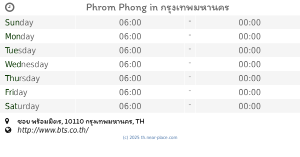
Phrom Phong
ซอย พร้อมมิตร, Khlong Tan, Khlong Toei
Subway station
read more
31.294 km
Punnawithi
Bang Chak, Phra Khanong
Subway station
read more
📑
all categories
Accounting
Administrative area level 1
Administrative area level 2
Airport
Amusement park
Aquarium
Art gallery
Atm
Bakery
Bank
Bar
Beauty salon
Bicycle store
Book store
Bowling alley
Bus station
Cafe
Campground
Car dealer
Car rental
Car repair
Car wash
Casino
Cemetery
Church
City hall
Clothing store
Colloquial area
Convenience store
Courthouse
Dentist
Department store
Doctor
Electrician
Electronics store
Embassy
Finance
Fire station
Florist
Food
Funeral home
Furniture store
Gas station
General contractor
Grocery or supermarket
Gym
Hair care
Hardware store
Health
Hindu Temple
Home goods store
Hospital
Insurance agency
Intersection
Jewelry store
Laundry
Lawyer
Library
Light rail station
Liquor store
Local government office
Locality
Locksmith
Lodging
Meal delivery
Meal takeaway
Mosque
Movie rental
Movie theater
Moving company
Museum
Natural feature
Neighborhood
Night club
Painter
Park
Parking
Pet store
Pharmacy
Physiotherapist
Place of worship
Plumber
Point of interest
Police
Political
Post office
Premise
Real estate agency
Restaurant
Roofing contractor
Route
Rv park, camping
School
Shoe store
Shopping mall
Spa
Stadium
Storage
Store
Subpremise
Subway station
Supermarket
Synagogue
Taxi stand
Train station
Transit station
Travel agency
University
Veterinary care
Zoo
sublocality level 1
sublocality level 2
↑