
no info
🕗 opening times
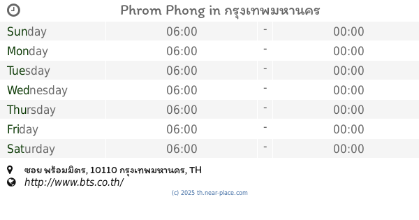
| Sunday | ⚠ | |||||
| Monday | ⚠ | |||||
| Tuesday | ⚠ | |||||
| Wednesday | ⚠ | |||||
| Thursday | ⚠ | |||||
| Friday | ⚠ | |||||
| Saturday | ⚠ | |||||
Rattanathibet Road, 11000, Amphoe Mueang Nonthaburi, Chang Wat Nonthaburi, TH Thailand
contacts phone: +66
larger map & directionsLatitude: 13.860159, Longitude: 100.5130833

วิมล วงษ์ทองดี
::เราอยุ่ตรงข้ามกับศูนย์ราชการค่ะ
อารัณย์ นาทอง
::ตั้งแต่มีสถานีเชื่อมต่อจากเตาปูนไปบางชื่อสะดวกไม่ต้องใช้เวลานานในการต่อสถานีจากรถประจำทางไปสถานีบางชื่อประหยัดเวลาในการเดินทางมากถึงจุดหมายตรงเวลา
Jai Prakash Ojha
::Started from August 2017. Use blue line MRT to goto TaoPoon and then transfer to purple LINE to goto Nonthaburi civic station
Prasit Huaykam
::ถ้าสร้างอีกสาย คนจะใช้เยอะมาก ดีต่อการจราจรในอนาคตมากๆ
Weeraya Chan
::สถานีกว้างมากกกกค่ะ ใช้ระบบเหรียญสัมผัสเช่นเดียวกับ MRT