Train station nearby Hua Takhe
Thailand
Train station nearby Hua Takhe
Hua Takhe
Lat Krabang Tajlandia
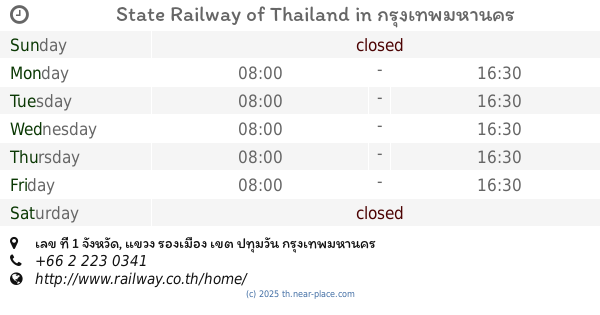
contacts phone
:
+66
Latitude:
13.7282437
, Longitude:
100.782578
read more
nearest Train station
775 m
Pra Chom Klao
Thailand
Train station
read more
10.148 km
Ban Thap Chang
Thailand
Train station
read more
18.278 km
หจก.โชคพัฒนายุทธ
Ramkhamhaeng Road, Hua Mak, Bang Kapi
Train station
read more
19.589 km
Sukhumvit 71
Thailand
Train station
read more
20.892 km
Khlong Tan
Thailand
Train station
read more
23.526 km
Sutthisan MRT Station
Ratchadaphisek Road, Samsen Nok, Huai Khwang
Train station
read more
23.734 km
Asok
Thailand
Train station
read more
24.781 km
Mae Nam Railway Station
1049, Chuea Phloeng Road, Chong Nonsi, Yan Nawa
Train station
read more
27.349 km
Bang Khen
Thailand
Train station
read more
27.457 km
Thung Song Hong
Thailand
Train station
read more
27.566 km
Bang Sue Junction
Bang Sue
Train station
read more
27.622 km
Pra Dipat
Thailand
Train station
read more
27.829 km
Lak Si
Talat Bang Khen, Lak Si
Train station
read more
28.193 km
Kan Kheha KM.19
Thailand
Train station
read more
28.766 km
Don Mueang New Market
Thailand
Train station
read more
28.768 km
State Railway of Thailand
เลข ที่ 1 จังหวัด, แขวง รองเมือง, เขต ปทุมวัน
Train station
read more
28.934 km
Don Muang Railway Station
Sanambin, Don Mueang
Train station
read more
28.978 km
Don Muang
Thailand
Train station
read more
31.396 km
Grand Canal
Thailand
Train station
read more
32.772 km
Lak Hok
Thanyaburi District
Train station
read more
33.006 km
Thonburi
Thailand
Train station
read more
33.72 km
ป้ายหยุดรถจรัลสนิทวงศ์
Thailand
Train station
read more
34.728 km
Purple Line Nonthaburi one station split
เลี่ยงเมืองนนทบุรี, Bang Kraso, Mueang Nonthaburi District
Train station
read more
42.209 km
Phuttamonthon Sai 2
Thailand
Train station
read more
46.52 km
Thung Si Thong
Bang Nam Chuet, Mueang Samut Sakhon District
Train station
read more
📑
all categories
Accounting
Administrative area level 1
Administrative area level 2
Airport
Amusement park
Aquarium
Art gallery
Atm
Bakery
Bank
Bar
Beauty salon
Bicycle store
Book store
Bowling alley
Bus station
Cafe
Campground
Car dealer
Car rental
Car repair
Car wash
Casino
Cemetery
Church
City hall
Clothing store
Colloquial area
Convenience store
Courthouse
Dentist
Department store
Doctor
Electrician
Electronics store
Embassy
Finance
Fire station
Florist
Food
Funeral home
Furniture store
Gas station
General contractor
Grocery or supermarket
Gym
Hair care
Hardware store
Health
Hindu Temple
Home goods store
Hospital
Insurance agency
Intersection
Jewelry store
Laundry
Lawyer
Library
Light rail station
Liquor store
Local government office
Locality
Locksmith
Lodging
Meal delivery
Meal takeaway
Mosque
Movie rental
Movie theater
Moving company
Museum
Natural feature
Neighborhood
Night club
Painter
Park
Parking
Pet store
Pharmacy
Physiotherapist
Place of worship
Plumber
Point of interest
Police
Political
Post office
Premise
Real estate agency
Restaurant
Roofing contractor
Route
Rv park, camping
School
Shoe store
Shopping mall
Spa
Stadium
Storage
Store
Subpremise
Subway station
Supermarket
Synagogue
Taxi stand
Train station
Transit station
Travel agency
University
Veterinary care
Zoo
sublocality level 1
sublocality level 2
↑