Subway station nearby Bang Chak
Coronavirus disease (COVID-19) Situation
confirmed cases
4770149
deaths
34586
Thailand
Subway station nearby Bang Chak
Bang Chak
Bang Chak, Phra Khanong, Bangkok 10260, Thailand
contacts phone
:
+66
Latitude:
13.696544
, Longitude:
100.605498
larger map & directions
read more
nearest Subway station
892 m
Punnawithi
Bang Chak, Phra Khanong
Subway station
read more
1.109 km
On Nut BTS Station
Thailand
Subway station
read more
1.899 km
Udom Suk
Thailand
Subway station
read more
2.584 km
Phra Khanong
Thailand
Subway station
read more
3.161 km
Bang Na
Sukhumvit Road, Bang Na
Subway station
read more
3.355 km
Ekkamai
Thailand
Subway station
read more
3.952 km
Bearing
Thailand
Subway station
read more
4.236 km
Thong Lo
Thailand
Subway station
read more
5.399 km
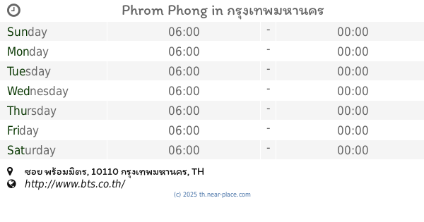
Phrom Phong
ซอย พร้อมมิตร, Khlong Tan, Khlong Toei
Subway station
read more
5.764 km
Queen Sirikit National Convention Centre
Thailand
Subway station
read more
6.303 km
Hua Mak
Suan Luang
Subway station
read more
6.631 km
Asok
Kamphaeng Phet 7 Road, Bang Kapi, Huai Khwang
Subway station
read more
6.665 km
Sukhumvit
Khlong Toei Nuea, Watthana
Subway station
read more
8.049 km
Phra Ram 9
Thailand
Subway station
read more
8.298 km
Si Lom
Thailand
Subway station
read more
10.084 km
Ratchathewi
Thanon Phetchaburi, Ratchathewi
Subway station
read more
10.242 km
Phaya Thai
Thanon Phaya Thai, Ratchathewi
Subway station
read more
11.411 km
Krung Thon Buri
Khlong Ton Sai, Khlong San
Subway station
read more
11.807 km
Ratchadaphisek
Din Daeng
Subway station
read more
12.217 km
Wongwian Yai
Khlong Ton Sai, Khlong San
Subway station
read more
12.836 km
MRT ลาดพร้าว
ซอย ลาดพร้าว 17, ซอย ลาดพร้าว 101, Chom Phon, Chatuchak
Subway station
read more
13.157 km
Pho Nimit
Ratchaphruek Road, Bukkhalo, Thon Buri
Subway station
read more
14.604 km
Tao Poon
558 ประชาราษฎร์ สาย 2, Bang Sue
Subway station
read more
14.865 km
Wutthakat
Wutthakat, Talat Phlu, Thon Buri
Subway station
read more
17.098 km
Wong Sawang
Thailand
Subway station
read more
📑
all categories
Accounting
Administrative area level 1
Administrative area level 2
Airport
Amusement park
Aquarium
Art gallery
Atm
Bakery
Bank
Bar
Beauty salon
Bicycle store
Book store
Bowling alley
Bus station
Cafe
Campground
Car dealer
Car rental
Car repair
Car wash
Casino
Cemetery
Church
City hall
Clothing store
Colloquial area
Convenience store
Courthouse
Dentist
Department store
Doctor
Electrician
Electronics store
Embassy
Finance
Fire station
Florist
Food
Funeral home
Furniture store
Gas station
General contractor
Grocery or supermarket
Gym
Hair care
Hardware store
Health
Hindu Temple
Home goods store
Hospital
Insurance agency
Intersection
Jewelry store
Laundry
Lawyer
Library
Light rail station
Liquor store
Local government office
Locality
Locksmith
Lodging
Meal delivery
Meal takeaway
Mosque
Movie rental
Movie theater
Moving company
Museum
Natural feature
Neighborhood
Night club
Painter
Park
Parking
Pet store
Pharmacy
Physiotherapist
Place of worship
Plumber
Point of interest
Police
Political
Post office
Premise
Real estate agency
Restaurant
Roofing contractor
Route
Rv park, camping
School
Shoe store
Shopping mall
Spa
Stadium
Storage
Store
Subpremise
Subway station
Supermarket
Synagogue
Taxi stand
Train station
Transit station
Travel agency
University
Veterinary care
Zoo
sublocality level 1
sublocality level 2
↑